Eryri (Snowdonia)
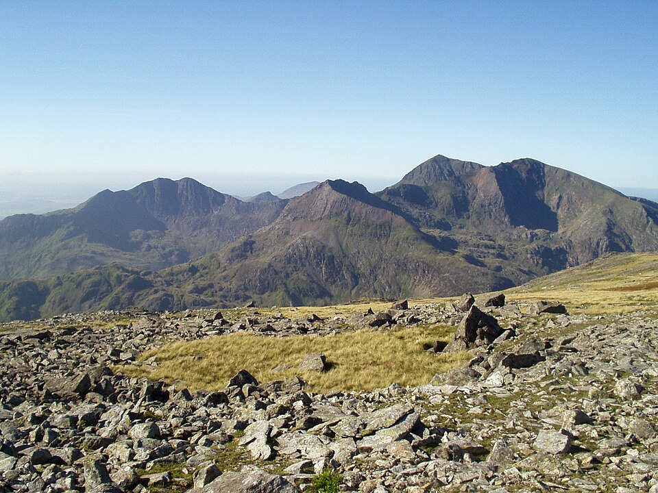
The highest and rockiest mountains in Wales, from Yr Wyddfa (Snowdon, 1,085 m) and the scrambling grounds of the Glyderau to the whaleback Carneddau and, further south, Cadair Idris and the rough Rhinogydd. Walking spans everything from heavily used paths on Yr Wyddfa to some of the quietest, stoniest ground in Wales. The park authority adopted the Welsh names Eryri and Yr Wyddfa in 2022.

- Country
- Wales
- Area
- 2,132 km²
- Designated
- 1951
- Listed hills
- 198
- Highest listed hill
- Snowdon - Yr Wyddfa 1085 m
Access in this park
Most of the high ground is mapped CRoW open access land with freedom to roam on foot. Wild camping needs the landowner’s permission, as everywhere in Wales.
Conditional Right to roam (Wales): Right to roam only on mapped CRoW open access land.
Permission needed Wild camping (Wales): Permission needed everywhere.
Designation as a park creates no right of access in itself — the law of Wales applies inside the boundary, and park byelaws, seasonal restrictions and closures can override the general position. This is general information, not legal advice. Full detail:access rights in Wales ·check a specific grid reference.
All 198 listed hills, tallest first
Every summit from our hill dataset whose summit point falls inside the park boundary. Follow a name for its full record, live summit weather and daylight times.
| # | Hill | Height | Classifications | Grid ref |
|---|---|---|---|---|
| 1 | Snowdon - Yr Wyddfa | 1085 m | HewittNuttallHistoric County Top+6 | SH609543 |
| 2 | Crib y Ddysgl | 1065.3 m | HewittNuttallFurth+1 | SH610551 |
| 3 | Carnedd Llewelyn | 1064 m | HewittNuttallCurrent County/UA Top+5 | SH683643 |
| 4 | Carnedd Dafydd | 1044 m | HewittNuttallTrail 100+3 | SH662630 |
| 5 | Glyder Fawr | 1000.9 m | HewittNuttallFurth+3 | SH642579 |
| 6 | Glyder Fach | 994.3 m | HewittNuttallTrail 100+2 | SH656582 |
| 7 | Pen yr Ole Wen | 978 m | HewittNuttallTrail 100+2 | SH655619 |
| 8 | Foel Grach | 975.4 m | HewittNuttallFurth+1 | SH688659 |
| 9 | Castell y Gwynt | 972 m | Nuttall | SH653581 |
| 10 | Yr Elen | 962 m | HewittNuttallFurth+1 | SH673651 |
| 11 | Y Garn | 947 m | HewittNuttallTrail 100+4 | SH630595 |
| 12 | Foel-fras | 944.1 m | HewittNuttallFurth+1 | SH696681 |
| 13 | Garnedd Uchaf | 925 m | HewittNuttallFurth+1 | SH686669 |
| 14 | Elidir Fawr | 924 m | HewittNuttallTrail 100+4 | SH611612 |
| 15 | Crib Goch | 923 m | HewittNuttallTrail 100+2 | SH624551 |
| 16 | Tryfan | 917.5 m | HewittNuttallTrail 100+4 | SH664593 |
| 17 | Aran Fawddwy | 905.6 m | HewittNuttallHistoric County Top+4 | SH862223 |
| 18 | Y Lliwedd | 897.9 m | HewittNuttallTrail 100+3 | SH622533 |
| 19 | Y Lliwedd East Top | 893.2 m | Nuttall | SH624532 |
| 20 | Cadair Idris - Penygadair | 892.7 m | HewittNuttallTrail 100+3 | SH711130 |
| 21 | Aran Benllyn | 885 m | HewittNuttallSimm | SH867242 |
| 22 | Moel Siabod | 872.2 m | HewittNuttallTrail 100+3 | SH705546 |
| 23 | Erw y Ddafad-ddu | 872 m | HewittNuttallSimm | SH864233 |
| 24 | Mynydd Moel | 863 m | HewittNuttallSimm | SH727136 |
| 25 | Arenig Fawr | 854 m | HewittNuttallMarilyn+2 | SH827369 |
| 26 | Llwytmor | 849 m | HewittNuttallSimm | SH689692 |
| 27 | Arenig Fawr South Top | 837 m | Nuttall | SH826366 |
| 28 | Pen yr Helgi Du | 832.6 m | HewittNuttallSimm | SH697630 |
| 29 | Foel-goch | 831 m | HewittNuttallSimm | SH628612 |
| 30 | Carnedd y Filiast | 821 m | HewittNuttallSimm | SH620627 |
| 31 | Lliwedd Bach | 819 m | Nuttall | SH627532 |
| 32 | Mynydd Perfedd | 813 m | Nuttall | SH623618 |
| 33 | Cyfrwy | 811 m | HewittNuttallSimm | SH703133 |
| 34 | Bera Bach | 806.5 m | Nuttall | SH672677 |
| 35 | Y Foel Goch | 805 m | HewittNuttallSimm | SH677582 |
| 36 | Foel Meirch | 798.7 m | Nuttall | SH658637 |
| 37 | Pen Llithrig y Wrach | 798.6 m | HewittNuttallMarilyn+2 | SH716622 |
| 38 | Bera Mawr | 793.7 m | Nuttall | SH674682 |
| 39 | Craig Cwm Amarch | 791.9 m | HewittNuttallSimm | SH710121 |
| 40 | Moel Hebog | 783.7 m | HewittNuttallTrail 100+3 | SH565469 |
| 41 | Glasgwm | 779 m | HewittNuttallMarilyn+2 | SH836194 |
| 42 | Drum | 771 m | HewittNuttallSimm | SH708695 |
| 43 | Moelwyn Mawr | 770 m | HewittNuttallMarilyn+2 | SH658448 |
| 44 | Gallt yr Ogof | 763 m | HewittNuttallSimm | SH685585 |
| 45 | Drosgl | 756.9 m | HewittNuttallSimm | SH663679 |
| 46 | Y Llethr | 756 m | HewittNuttallMarilyn+2 | SH661257 |
| 47 | Moel Llyfnant | 751 m | HewittNuttallMarilyn+2 | SH808351 |
| 48 | Diffwys | 750.4 m | HewittNuttallHuMP+1 | SH661234 |
| 49 | Yr Aran | 747.2 m | HewittNuttallTrail 100+3 | SH604515 |
| 50 | Craig Eigiau | 735 m | Nuttall | SH713654 |
| 51 | Craig Cwm Silyn | 734 m | HewittNuttallMarilyn+2 | SH525502 |
| 52 | Rhobell Fawr | 734 m | HewittNuttallMarilyn+2 | SH786256 |
| 53 | Moel Eilio | 726 m | HewittNuttallMarilyn+2 | SH555577 |
| 54 | Carnedd y Filiast North Top | 720 m | Nuttall | SH617631 |
| 55 | Llechog | 720 m | Nuttall | SH606567 |
| 56 | Rhinog Fawr | 720 m | HewittNuttallTrail 100+3 | SH656290 |
| 57 | Arenig Fawr South Ridge Top | 714 m | Nuttall | SH827359 |
| 58 | Moelwyn Bach | 712 m | HewittNuttallHuMP+1 | SH660437 |
| 59 | Rhinog Fach | 711.6 m | HewittNuttallMarilyn+2 | SH664270 |
| 60 | Trum y Ddysgl | 709.7 m | HewittNuttallMarilyn+2 | SH544516 |
| 61 | Garnedd-goch | 700 m | Nuttall | SH511495 |
| 62 | Mynydd Mawr | 698 m | HewittNuttallMarilyn+2 | SH539546 |
| 63 | Mynydd Drws-y-coed | 695 m | HewittNuttallTrail 100+1 | SH548518 |
| 64 | Cnicht | 690.9 m | HewittNuttallTrail 100+2 | SH645466 |
| 65 | Cnicht North Top | 690.2 m | Nuttall | SH647468 |
| 66 | Craigysgafn | 689.9 m | Nuttall | SH659443 |
| 67 | Foel Hafod-fynydd | 689 m | HewittNuttallSimm | SH877227 |
| 68 | Arenig Fach | 688.8 m | HewittNuttallTrail 100+3 | SH820415 |
| 69 | Gwaun y Llwyni | 685.5 m | HewittNuttallSimm | SH857204 |
| 70 | Pen y Brynfforchog | 684.9 m | HewittNuttallSimm | SH817179 |
| 71 | Gau Graig | 683.7 m | Nuttall | SH743140 |
| 72 | Crib-y-rhiw | 681.2 m | Nuttall | SH663248 |
| 73 | Maesglase | 678.5 m | HewittNuttallTrail 100+3 | SH817150 |
| 74 | Creigiau Gleision | 675.9 m | HewittNuttallMarilyn+2 | SH729615 |
| 75 | Moel Cynghorion | 674 m | HewittNuttallMarilyn+2 | SH586563 |
| 76 | Ysgafell Wen | 672.2 m | HewittNuttallSimm | SH666481 |
| 77 | Waun-oer | 670 m | HewittNuttallHuMP+1 | SH785147 |
| 78 | Esgeiriau Gwynion | 669.9 m | HewittNuttallMarilyn+2 | SH889236 |
| 79 | Ysgafell Wen North Top | 669.4 m | HewittNuttallSimm | SH663485 |
| 80 | Carnedd y Filiast | 669 m | HewittNuttallMarilyn+2 | SH871445 |
| 81 | Foel Cedig | 667.5 m | HewittNuttallMarilyn+2 | SH981283 |
| 82 | Tarren y Gesail | 666.9 m | HewittNuttallMarilyn+2 | SH710058 |
| 83 | Dduallt | 662.8 m | HewittNuttallHuMP+1 | SH810273 |
| 84 | Craig-las | 661 m | HewittNuttallHuMP+1 | SH677135 |
| 85 | Foel Rhudd | 659 m | Nuttall | SH895239 |
| 86 | Y Groes Fagl | 659 m | Nuttall | SH988290 |
| 87 | Ysgafell Wen Far North Top | 659 m | Nuttall | SH663487 |
| 88 | Cribin Fawr | 658.8 m | HewittNuttallSimm | SH794152 |
| 89 | Moel yr Ogof | 655 m | HewittNuttallHuMP+1 | SH556478 |
| 90 | Mynydd Tal-y-mignedd | 653 m | HewittNuttallSimm | SH535513 |
| 91 | Waun Garnedd-y-Filiast | 650.9 m | Nuttall | SH874452 |
| 92 | Foel Cwm-Sian Llwyd | 648 m | HewittNuttallSimm | SH995313 |
| 93 | Pen y Boncyn Trefeilw | 644.2 m | HewittNuttallSimm | SH962283 |
| 94 | Carnedd Llechwedd-llyfn | 644.1 m | Nuttall | SH857444 |
| 95 | Diffwys West Top | 643.1 m | Nuttall | SH648229 |
| 96 | Gyrn Wigau | 643 m | Nuttall | SH654675 |
| 97 | Moel Lefn | 638 m | HewittNuttallSimm | SH552485 |
| 98 | Tarrenhendre | 634 m | HewittNuttallMarilyn+2 | SH682041 |
| 99 | Y Garn | 633 m | Nuttall | SH551526 |
| 100 | Gwaun Lydan | 632 m | Nuttall | SH880211 |
| 101 | Creigiau Gleision North Top | 631.8 m | HewittNuttallSimm | SH733622 |
| 102 | Pen yr Allt Uchaf | 630.1 m | HewittNuttallSimm | SH870196 |
| 103 | Stac Rhos | 629.8 m | Nuttall | SH969279 |
| 104 | Foel Gron | 629 m | HewittNuttallSimm | SH560568 |
| 105 | Y Garn | 629 m | HewittNuttallMarilyn+2 | SH702230 |
| 106 | Foel y Geifr | 626.2 m | HewittNuttallHuMP+1 | SH937275 |
| 107 | Pen y Castell | 623.5 m | Nuttall | SH721688 |
| 108 | Moel Ysgyfarnogod | 623 m | HewittNuttallMarilyn+2 | SH658345 |
| 109 | Craig-y-llyn | 622 m | HewittNuttallHuMP+1 | SH665119 |
| 110 | Craiglwyn | 621.9 m | Nuttall | SH730608 |
| 111 | Waun Camddwr | 621.7 m | Nuttall | SH847205 |
| 112 | Gallt y Wenallt | 619.7 m | Nuttall | SH642532 |
| 113 | Gallt y Daren | 619.4 m | HewittNuttallHuMP+1 | SH778344 |
| 114 | Foel Boeth | 615.4 m | Nuttall | SH779342 |
| 115 | Foel Penolau | 614.4 m | HewittNuttallSimm | SH661348 |
| 116 | Llechwedd Du | 613.4 m | HewittNuttallSimm | SH893223 |
| 117 | Foel Goch | 612.7 m | HewittNuttallSimm | SH943290 |
| 118 | Trum y Gwragedd | 611.1 m | Nuttall | SH941284 |
| 119 | Tal y Fan | 610 m | HewittNuttallMarilyn+2 | SH729726 |
| 120 | Mynydd Graig Goch | 609.8 m | HewittNuttallSimm | SH497485 |
| 121 | Moel Meirch | 608.9 m | SimmDewey | SH661503 |
| 122 | Craig Fach | 608.8 m | SimmDewey | SH634552 |
| 123 | Foel Tyn-y-fron | 605.7 m | SimmDewey | SH918257 |
| 124 | Foel Goch | 604.5 m | SimmDewey | SH571563 |
| 125 | Craig Portas | 604.2 m | SimmDewey | SH801141 |
| 126 | Y Gribin | 600.5 m | SimmDewey | SH843177 |
| 127 | Foel Lwyd | 600.2 m | SimmDewey | SH720723 |
| 128 | Y Ro Wen | 598.6 m | HuMPDewey | SH745500 |
| 129 | Moel Llygoed | 598 m | HuMPDewey | SH925193 |
| 130 | Mynydd Braich-goch | 597 m | Dewey | SH729072 |
| 131 | Craig Ddrwg | 596 m | Dewey | SH656331 |
| 132 | Foel-boeth | 596 m | Dewey | SH864430 |
| 133 | Clip | 595 m | Dewey | SH654329 |
| 134 | Cefn Coch | 592.9 m | Dewey | SH923266 |
| 135 | Carnedd y Cribau | 591 m | Dewey | SH676536 |
| 136 | Foel Figenau | 590 m | HuMPDewey | SH916284 |
| 137 | Craig y Grut | 589 m | Dewey | SH631210 |
| 138 | Moelfre | 589 m | MarilynHuMPDewey | SH626245 |
| 139 | Yr Arddu | 589 m | Dewey | SH673507 |
| 140 | Y Gamallt | 588 m | HuMPDewey | SH751447 |
| 141 | Craig Portas East Top | 587 m | Dewey | SH808142 |
| 142 | Foel-fras | 586 m | Dewey | SH728481 |
| 143 | Graig Goch | 586 m | HuMPDewey | SH714084 |
| 144 | Moel Wnion | 579.9 m | HuMPDewey | SH649697 |
| 145 | Moel y Feidiog | 577.6 m | Dewey | SH781324 |
| 146 | Moel yr Wden | 572.2 m | Dewey | SH780356 |
| 147 | Craig Wion | 565.6 m | Dewey | SH664319 |
| 148 | Pen Ochr y Bwlch | 564.3 m | Dewey | SH809172 |
| 149 | Yr Orsedd | 559 m | Dewey | SH693715 |
| 150 | Graig Wen | 555.6 m | HuMPDewey | SH739394 |
| 151 | Craig Llyn Du | 553 m | Dewey | SH655295 |
| 152 | Moel-ddu | 552.3 m | MarilynHuMPDewey | SH579442 |
| 153 | Y Garnedd | 552 m | Dewey | SH741431 |
| 154 | Tarren Cwm-ffernol | 551 m | Dewey | SH659023 |
| 155 | Moel Ymenyn | 550 m | Dewey | SH839346 |
| 156 | Mynydd Bryn-llech | 548 m | Dewey | SH805314 |
| 157 | Craig Wen | 546.3 m | Dewey | SH729602 |
| 158 | Braich Ddu | 546 m | Dewey | SH645120 |
| 159 | Moel Eilio | 546 m | Dewey | SH747659 |
| 160 | Ceiswyn | 544.1 m | HuMPDewey | SH745109 |
| 161 | Foel Benddin | 541.9 m | Dewey | SH853165 |
| 162 | Gyrn | 541.3 m | Dewey | SH647687 |
| 163 | Foel Boeth | 541 m | Dewey | SH834337 |
| 164 | Mynydd Nodol | 539 m | MarilynHuMPDewey | SH865393 |
| 165 | Rhiwaedog-uwch-afon | 539 m | Dewey | SH938313 |
| 166 | Carnedd Iago | 538 m | Dewey | SH782406 |
| 167 | Graig Ddu | 537 m | Dewey | SH888429 |
| 168 | Moel y Gyrafolen | 536.8 m | Dewey | SH672352 |
| 169 | Foel-ganol | 536 m | Dewey | SH688715 |
| 170 | Craig yr Hafod | 533.6 m | Dewey | SH888437 |
| 171 | Mynydd Maes-glas | 532 m | Dewey | SH914147 |
| 172 | Moel Cae'r-defaid West Top | 531.1 m | Dewey | SH800246 |
| 173 | Foel Fawr | 528 m | Dewey | SH728392 |
| 174 | Pen y Bedw East Top | 527.8 m | Dewey | SH784470 |
| 175 | Lledwyn Mawr | 526 m | Dewey | SH904287 |
| 176 | Craig y Benglog | 525.2 m | Dewey | SH805244 |
| 177 | Moel Dyrnogydd | 524 m | Dewey | SH695491 |
| 178 | Bryn-pig | 523 m | Dewey | SH766306 |
| 179 | Rhobell Ganol | 521 m | Dewey | SH785274 |
| 180 | Bryn Banog | 520 m | Dewey | SH576457 |
| 181 | Craig Dolfudr North Top | 519 m | Dewey | SH822317 |
| 182 | Moel Morwynion | 518.4 m | Dewey | SH663306 |
| 183 | Craig Dolfudr | 518 m | Dewey | SH828310 |
| 184 | Foel Ystrodur Fawr | 518 m | Dewey | SH814340 |
| 185 | Mynydd Egryn | 517 m | Dewey | SH623194 |
| 186 | Mynydd Fron-fraith | 514 m | Dewey | SH747117 |
| 187 | Pen Foel-y-ffridd | 514 m | HuMPDewey | SH891188 |
| 188 | Pen Trum-gwr | 512.6 m | Dewey | SH651029 |
| 189 | Bryn-mawr | 510.4 m | Dewey | SH801442 |
| 190 | Foel Boeth | 509 m | Dewey | SH804477 |
| 191 | Moel Cae-howel | 508 m | Dewey | SH978330 |
| 192 | Esgair Berfa | 507 m | Dewey | SH637095 |
| 193 | Rhobell-y-big | 504 m | Dewey | SH782282 |
| 194 | Moel Oernant | 502.8 m | HuMPDewey | SH742340 |
| 195 | Mynydd Rhyd-galed | 502 m | Dewey | SH699043 |
| 196 | Y Garnedd North Top | 502 m | Dewey | SH743440 |
| 197 | Cefn Cyfarwydd | 501.7 m | Dewey | SH752630 |
| 198 | Ffridd yr Allt-llwyd | 500.4 m | Dewey | SH797296 |
Hill data from the Database of British & Irish Hills v18.3 (CC BY 4.0); park boundaries from the Office for National Statistics (OGL v3.0). Hills are assigned to a park by summit position, so a top just outside the boundary will not appear here even if the walk starts inside it.
Long-distance paths through Eryri (Snowdonia)
6 waymarked long-distance routes cross the park boundary. Distances are for the whole route, not just the section inside the park.
| Route | Total length | Countries |
|---|---|---|
| Cambrian Way | 483 km · 300 mi | Wales |
| Wales Coast Path | 321 km · 200 mi | Wales |
| Snowdonia Slate Trail | 135 km · 84 mi | Wales |
| Wales Coast Path (Meirionnydd) | 104 km · 64 mi | Wales |
| North Wales Path | 97 km · 60 mi | Wales |
| North Wales Pilgrim's Way | 51 km · 32 mi | Wales |
Route lines © OpenStreetMap contributors (ODbL); park crossings computed by OpenFell against the ONS park boundary. See all UK long-distance paths.
Plan a walk here
- Walking-time calculator — Naismith with terrain and fitness corrections.
- Daylight safety planner — set your turnaround against sunset.
- Access checker — what a specific grid reference allows.
- Access rights in Wales — roaming, paths, camping and dogs in detail.
- Safety notes — conditions change fast; build in margin.