Yorkshire Dales
Classic limestone country: the Three Peaks of Whernside (736 m), Ingleborough and Pen-y-ghent, crag-rimmed dales, extensive cave systems, and drystone walls and field barns in every view. The park grew westward in 2016 to take in more of the Howgill and Orton fells. Walking ranges from riverside dale paths to long moorland rounds.
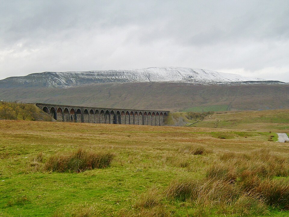

- Country
- England
- Area
- 2,179 km²
- Designated
- 1954
- Listed hills
- 73
- Highest listed hill
- Whernside 736.6 m
Access in this park
Most of the high fell and moorland is mapped CRoW open access land; the valley floors rely on rights of way. Wild camping needs the landowner’s permission.
Conditional Right to roam (England): Right to roam only on mapped CRoW open access land.
Conditional Wild camping (England): Permission needed — except on the Dartmoor commons.
Designation as a park creates no right of access in itself — the law of England applies inside the boundary, and park byelaws, seasonal restrictions and closures can override the general position. This is general information, not legal advice. Full detail:access rights in England ·check a specific grid reference.
All 73 listed hills, tallest first
Every summit from our hill dataset whose summit point falls inside the park boundary. Follow a name for its full record, live summit weather and daylight times.
| # | Hill | Height | Classifications | Grid ref |
|---|---|---|---|---|
| 1 | Whernside | 736.6 m | HewittNuttallCurrent County/UA Top+3 | SD738815 |
| 2 | Ingleborough | 723.3 m | HewittNuttallTrail 100+3 | SD741745 |
| 3 | Great Shunner Fell | 715.7 m | HewittNuttallMarilyn+2 | SD848972 |
| 4 | High Seat | 709 m | HewittNuttallHuMP+1 | NY802012 |
| 5 | Wild Boar Fell | 708.4 m | HewittNuttallMarilyn+2 | SD758987 |
| 6 | Great Whernside | 704 m | HewittNuttallMarilyn+2 | SE002739 |
| 7 | Buckden Pike | 701.6 m | HewittNuttallMarilyn+2 | SD960787 |
| 8 | Archy Styrigg | 695 m | Nuttall | NY802003 |
| 9 | Pen-y-ghent | 694.1 m | HewittNuttallMarilyn+2 | SD838733 |
| 10 | Hugh Seat | 688.1 m | Nuttall | SD809991 |
| 11 | Great Coum | 686.4 m | HewittNuttallMarilyn+2 | SD700835 |
| 12 | Swarth Fell | 681 m | HewittNuttallSimm | SD755966 |
| 13 | Plover Hill | 679.9 m | HewittNuttallSimm | SD849752 |
| 14 | Baugh Fell - Tarn Rigg Hill | 678.4 m | HewittNuttallMarilyn+2 | SD740916 |
| 15 | The Calf | 676.7 m | HewittNuttallTrail 100+3 | SD667970 |
| 16 | Knoutberry Haw | 675.7 m | Nuttall | SD731919 |
| 17 | Calders | 675.4 m | HewittNuttallSimm | SD670960 |
| 18 | Lovely Seat | 674.8 m | HewittNuttallHuMP+1 | SD879950 |
| 19 | Great Knoutberry Hill | 672.5 m | HewittNuttallMarilyn+2 | SD788871 |
| 20 | Rogan's Seat | 671.6 m | HewittNuttallMarilyn+2 | NY919030 |
| 21 | Dodd Fell Hill | 668 m | HewittNuttallMarilyn+2 | SD841845 |
| 22 | Water Crag | 668 m | Nuttall | NY928046 |
| 23 | Fountains Fell | 667.8 m | HewittNuttallMarilyn+2 | SD864715 |
| 24 | Sails | 666.6 m | HewittNuttallSimm | SD808965 |
| 25 | Fountains Fell South Top | 663.4 m | Nuttall | SD868707 |
| 26 | Simon Fell | 649 m | HewittNuttallSimm | SD754751 |
| 27 | Yockenthwaite Moor | 643 m | HewittNuttallSimm | SD909810 |
| 28 | Fell Head | 640 m | HewittNuttallSimm | SD649981 |
| 29 | Yarlside | 639.2 m | HewittNuttallMarilyn+2 | SD685985 |
| 30 | Green Hill | 628.2 m | Nuttall | SD702821 |
| 31 | Gragareth | 628 m | HewittNuttallCurrent County/UA Top+1 | SD688793 |
| 32 | Darnbrook Fell | 624 m | HewittNuttallSimm | SD884727 |
| 33 | Randygill Top | 624 m | HewittNuttallHuMP+1 | NY687000 |
| 34 | Bush Howe | 622.3 m | Nuttall | SD659980 |
| 35 | Drumaldrace | 614 m | HewittNuttallSimm | SD873867 |
| 36 | Birks Fell | 610.4 m | HewittNuttallMarilyn+2 | SD918763 |
| 37 | Calf Top | 609.6 m | HewittNuttallMarilyn+2 | SD664856 |
| 38 | Horse Head Moor | 609.3 m | SimmDewey | SD894769 |
| 39 | Arant Haw | 605 m | SimmDewey | SD662946 |
| 40 | Green Bell | 605 m | SimmDewey | NY698010 |
| 41 | Little Whernside | 605 m | SimmDewey | SE028776 |
| 42 | High Green Field Knott | 603.2 m | SimmDewey | SD846784 |
| 43 | Woldside | 595.3 m | Dewey | SD874830 |
| 44 | Simon's Seat | 587 m | Dewey | SD659999 |
| 45 | Hooksey | 586 m | Dewey | NY685008 |
| 46 | Brown Haw | 584 m | Dewey | SD995799 |
| 47 | Oxnop Common - Blackstone | 584 m | Dewey | SD924947 |
| 48 | Great Pinseat | 583 m | Dewey | NY970026 |
| 49 | Hazelgill Knott | 578 m | Dewey | SD672996 |
| 50 | Kensgriff | 574 m | Dewey | SD688992 |
| 51 | Naughtberry Hill | 573 m | Dewey | SD977817 |
| 52 | Pickerstone Ridge | 565 m | Dewey | SD994946 |
| 53 | Park Fell | 564 m | Dewey | SD762769 |
| 54 | Wold Fell | 559 m | Dewey | SD790848 |
| 55 | Aye Gill Pike | 556.4 m | MarilynHuMPDewey | SD720886 |
| 56 | Hoove | 554.6 m | MarilynHuMPDewey | NZ001069 |
| 57 | Grizedales | 553 m | HuMPDewey | SD868643 |
| 58 | Height of Hazely | 553 m | HuMPDewey | SE037859 |
| 59 | Tarn Seat | 551 m | Dewey | SD956943 |
| 60 | Rye Loaf Hill | 547 m | Dewey | SD864633 |
| 61 | Kirkby Fell | 546.4 m | Dewey | SD873635 |
| 62 | Redshaw Moss | 545 m | Dewey | SD813846 |
| 63 | West Fell | 542 m | Dewey | NY670015 |
| 64 | Castle Knott | 538 m | Dewey | SD656841 |
| 65 | Parson's Pulpit | 538 m | HuMPDewey | SD918687 |
| 66 | Blea Moor | 535 m | HuMPDewey | SD772825 |
| 67 | Harland Hill | 535 m | Dewey | SE028842 |
| 68 | Uldale Head | 532 m | HuMPDewey | NY640000 |
| 69 | Proctor High Mark | 531 m | Dewey | SD937676 |
| 70 | Harter Fell | 521 m | HuMPDewey | NY721002 |
| 71 | Blaydike Moss | 510 m | Dewey | SD852772 |
| 72 | Cracoe Fell | 507.8 m | MarilynHuMPDewey | SD993588 |
| 73 | Cam Rakes | 503 m | HuMPDewey | SD839809 |
Hill data from the Database of British & Irish Hills v18.3 (CC BY 4.0); park boundaries from the Office for National Statistics (OGL v3.0). Hills are assigned to a park by summit position, so a top just outside the boundary will not appear here even if the walk starts inside it.
Long-distance paths through Yorkshire Dales
10 waymarked long-distance routes cross the park boundary. Distances are for the whole route, not just the section inside the park.
| Route | Total length | Countries |
|---|---|---|
| Pennine WayNational Trail | 411 km · 256 mi | England, Scotland |
| Coast to Coast WalkNational Trail | 303 km · 188 mi | England |
| Lady Anne's Way | 155 km · 97 mi | England |
| Dales High Way | 144 km · 89 mi | England |
| Dales Way | 129 km · 80 mi | England |
| Ribble Way | 113 km · 70 mi | England |
| Herriot Way | 80 km · 50 mi | England |
| Airedale Way | 77 km · 48 mi | England |
| 6 Dales Trail | 59 km · 37 mi | England |
| Three Peaks Walk | 38 km · 24 mi | England |
Route lines © OpenStreetMap contributors (ODbL); park crossings computed by OpenFell against the ONS park boundary. See all UK long-distance paths.
Plan a walk here
- Walking-time calculator — Naismith with terrain and fitness corrections.
- Daylight safety planner — set your turnaround against sunset.
- Access checker — what a specific grid reference allows.
- Access rights in England — roaming, paths, camping and dogs in detail.
- Safety notes — conditions change fast; build in margin.