Llwytmor
One classification here — Simm — belongs to a list OpenFell holds only part of, so it has no list page. See how far the coverage goes.

- Height
- 849 m · 2,785 ft
- Prominence
- 73 m
- Grid reference
- SH 68950 69227
- Coordinates
- 53.20390, -3.96356
- County / area
- Gwynedd
- Region
- Snowdonia
- OS Landranger
- 115
- OS Explorer
- OL17E OL17W
- Summit feature
- small cairn
- Key col
- SH691689 (776 m)
About Llwytmor
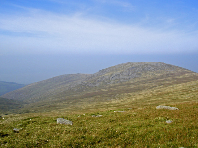
Llwytmor is a satellite peak of Foel-fras in the Carneddau, the 27th highest summit in Wales at 849 m. The top carries boulderfields, a shelter and several cairns, and Carneddau mountain ponies graze the slopes all year.
Ordnance Survey maps into the 1960s gave the name as Llwydmor — llwyd being Welsh for grey — and the later 't' is likely a typographical slip. The full form, Llwytmor Uchaf, means roughly "upper big and grey", the second element from mawr.
On a clear day the northward view reaches the Menai Strait and Anglesey, and in exceptional conditions the Isle of Man across the Irish Sea, along with the Lake District and the Wicklow Mountains.
Background written from facts in the Wikipedia article on Llwytmor (CC BY-SA 4.0). Heights, prominence and grid references come from the Database of British & Irish Hills, not from Wikipedia.
Access rights here
Conditional Right to roam: Right to roam only on mapped CRoW open access land.
Permission needed Wild camping: Permission needed everywhere.
General position for Wales — local byelaws, seasonal restrictions and closures can override it. Full details: access rights in Wales ·check another location.
Daylight at this summit today
- Sunrise
- —
- Sunset
- —
- Daylight
- —
- Civil twilight ends
- —
Computed astronomically for 53.204, -3.964. Plan your finish with the daylight safety planner.
Summit weather live
Loading forecast for the summit (849 m)…
Forecast adjusted to summit altitude. Weather data from MET Norway (CC BY 4.0).
Long-distance paths past this hill
One waymarked long-distance route runs within 2.5 km of the summit — useful if you are linking this hill into a longer walk, or want a made path for the approach.
| Route | Total length | From summit |
|---|---|---|
| North Wales Path | 97 km | 2.3 km |
Route lines © OpenStreetMap contributors (ODbL); distance from the summit computed by OpenFell.
Reaching Llwytmor by train
2 National Rail stations sit within 8 km of the summit — close enough to make a car-free day of it. Distances are straight lines, not walking routes.
| Station | From summit | Summit lies |
|---|---|---|
| Llanfairfechan | 6.1 km | S of the station |
| Penmaenmawr | 7.9 km | S of the station |
Each station page lists every hill in its reach, long-distance paths from the door and a live-times link — see all stations with hills in reach. Station positions from NaPTAN (OGL v3.0).
Get food nearby
3 places to eat or drink within 10 km of the summit, rated under the Food Hygiene Rating Scheme (Scotland runs its own Food Hygiene Information Scheme, a pass/fail equivalent).
| Place | Type | Rating | Distance |
|---|---|---|---|
| Caffi Almas | Restaurant/Cafe/Canteen | 4 out of 5 | 4.9 km · NW |
| LDC Catering (Llanfairfechan Golf Club) | Restaurant/Cafe/Canteen | 4 out of 5 | 5 km · N |
| Llanfair Arms | Pub/bar/nightclub | 4 out of 5 | 5.4 km · N |
Classifications and ratings are the local authority's own and can be coarse — this is a lead, not a guarantee of opening hours or that food is served to non-residents. Follow a name through to the official rating page to check, and confirm before you rely on it.
Food hygiene data from the Food Standards Agency and Food Standards Scotland (Open Government Licence v3.0). Distances and directions computed by OpenFell from the summit.
Which hill this one belongs to
Llwytmor is not counted as an independent hill in its own right. In prominence terms it belongs to Carnedd Llewelyn (1,064 m) — the nearest Marilyn you can reach from this summit without first dropping below its key col, 776 m.
Grouping is by prominence alone: a summit belongs to the nearest higher Marilyn it connects to without a deeper intervening col. Over a large massif that can gather hills no one would walk in a single day, and which few would describe as parts of the same mountain — it is a measure of independence, not a suggested route.