Bardon Hill
3 classifications here — Current County/UA Top, Marilyn and HuMP — belong to lists OpenFell holds only part of, so they have no list page. See how far the coverage goes.

- Height
- 279.9 m · 918 ft
- Prominence
- 172 m
- Grid reference
- SK 46082 13193
- Coordinates
- 52.71442, -1.31928
- County / area
- Leicestershire
- County top
- Highest point of Leicestershire
- OS Landranger
- 129
- OS Explorer
- 245E
- Summit feature
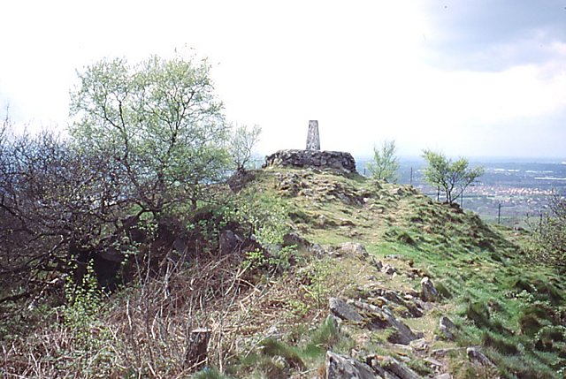
- rock tor N of communications mast
- Key col
- SP431909 (108 m)
About Bardon Hill
Bardon Hill is the highest point in Leicestershire and has long been valued for the reach of its view. On a clear day the Malvern and Shropshire Hills at 50 to 60 miles, Derbyshire summits at 30 to 40, and Lincoln Cathedral nearly 50 miles off all come into sight, though the Sugar Loaf in South Wales, sometimes claimed, is over 90 miles away and cannot be seen. Writers were making large claims by the 1830s: John Curtis put the view at more than 5,000 square miles, a twelfth of England and Wales, while Potter reckoned it took in nearly a quarter and called it one of the most extraordinary points of view in Nature.
That same commanding position drew telecommunications, and transmitters and radio masts have replaced the old Summer House and Queen Adelaide's Bower. Two masts stand near the top; the smaller was built for the BBC as an outside-broadcast link to the Sutton Coldfield transmitter, with the service later moved to the larger mast, originally an electricity company structure and now owned by Cellnex, carrying the NOW Leicester DAB service. The hill is also a 13.1-hectare biological SSSI, in the parish of Bardon east of Coalville.
Background written from facts in the Wikipedia article on Bardon Hill (CC BY-SA 4.0). Heights, prominence and grid references come from the Database of British & Irish Hills, not from Wikipedia.
Access rights here
Conditional Right to roam: Right to roam only on mapped CRoW open access land.
Permission needed Wild camping: Needs the landowner's permission — the Dartmoor commons are the only exception in England.
General position for England — local byelaws, seasonal restrictions and closures can override it. Full details: access rights in England ·check another location.
Daylight at this summit today
- Sunrise
- —
- Sunset
- —
- Daylight
- —
- Civil twilight ends
- —
Computed astronomically for 52.714, -1.319. Plan your finish with the daylight safety planner.
Summit weather live
Loading forecast for the summit (280 m)…
Forecast adjusted to summit altitude. Weather data from MET Norway (CC BY 4.0).
Finding the summit
trig point at SK 45993 13199 is lower.
The recorded summit point is rock tor N of communications mast. That distinction matters on broad or flat tops, where the obvious cairn is not always the true high point.
- Record revised
- 16-Aug-20
- Drop measured from
- SP431909 · 108 m
Survey notes are field observations recorded in the Database of British & Irish Hills (v18.3, CC BY 4.0) by the hill-surveying community.
Long-distance paths past this hill
One waymarked long-distance route runs within 2.5 km of the summit — useful if you are linking this hill into a longer walk, or want a made path for the approach.
| Route | Total length | From summit |
|---|---|---|
| Ivanhoe Way | 60 km | over the top |
Route lines © OpenStreetMap contributors (ODbL); distance from the summit computed by OpenFell.
Get food nearby
3 places to eat or drink within 10 km of the summit, rated under the Food Hygiene Rating Scheme (Scotland runs its own Food Hygiene Information Scheme, a pass/fail equivalent).
| Place | Type | Rating | Distance |
|---|---|---|---|
| Golden Fry | Takeaway/sandwich shop | 5 out of 5 | 1.2 km · NW |
| The Centre Cafe | Restaurant/Cafe/Canteen | 5 out of 5 | 1.2 km · NW |
| 2 For 1 Pizza | Takeaway/sandwich shop | 5 out of 5 | 1.3 km · NW |
Classifications and ratings are the local authority's own and can be coarse — this is a lead, not a guarantee of opening hours or that food is served to non-residents. Follow a name through to the official rating page to check, and confirm before you rely on it.
Food hygiene data from the Food Standards Agency and Food Standards Scotland (Open Government Licence v3.0). Distances and directions computed by OpenFell from the summit.